In Arizona we stayed at the KOA campground in Apache Junction, east of Phoenix. It's bounded with the Superstition Mountains, a federal Wilderness area, on the east.
The campground was nice but the price for a tentsite without electricity was kind of steep: $ 25 + tax. We are so used to stay in FamCamps on military bases/rec.areas and pay between $ 5 - $ 12 a night. Other then that the campground was good. Met a lot of nice people.

We did the Turquoise Trail in NM and next on our program was another trail: the Apache Trail. Which starts near the campground on hwy. 88. The Apache Trail is a 40-mile road winding through the Superstition Mountains. Originally used as a migration route by the Apache Indians, it eventually became a stagecoach route and now a scenic drive. Don't think of a nice paved wide road all the way. It's a paved road until Tortilla Flat, about 15 miles........
Entering Tortilla Flat. This is an authentic remnant of an old west town, nestled in the midst of the Tonto National Forest, in the Superstition Mountain Range. Tortilla Flat was a stop for gold miners and a post office for people around the area. It has now a population of 6. It consists of a restaurant, gift shop, small museum, post office and campground.

The hanging man.

Money bills from visitors all around the world.

Back on the road.


.....................but five miles past Tortilla Flat, the Apache Trail turns into a dirt and gravel road for about 22 miles and ends at the Roosevelt Dam. It winds through the mountains with fantastic views. It was not a pleasant drive, the road was like a washboard. It wasn't good for our rental car. I think we were not even allowed to take this car onto a dirt road! The 22 miles took us about 4 hours!!!, including the photo stops. We had to drive about 5-10 miles an hour as we were afraid something would happen to the car. The road was extremely bumpy. The Fish Creek Hill area was scary (to me). The drive turns into a one-lane, cliff-hanging road that descends more than 1,000 feet .
There are guard rails on the side of the road, but cars do drive off the cliff.

There are guard rails on the side of the road, but cars do drive off the cliff.
The pictures of this part didn't come out good so I posted a video off YouTube (see above: Fish Creek Hill).

After this scary part we continued on this dirt road and drove along beautiful Apache Lake toward Roosevelt Dam.
Apache Lake is a man-made reservoir that is about 17 miles long and provides more spectacular views from the road.


See how the road winds through the mountains.


Roosevelt Dam where the dirt road ends......

The dam serves the Phoenix area in supplying water and electricity.


Driving back I surely recommend using the US-30 through Globe. No one should go back the way they came as it will be dark and scary on the way back. We returned to Apache Junction in about
1 1/2 hours !

We celebrated the "Dia de los Muertos" ( Day of the Dead) at the Mesa Arts Center. It's a Mexican celebration and a public holiday overthere but it is celebrated in certain parts of USA as well. Arizona is one of them. A significant number of people from Mexico and with ancestors from Mexico live in Arizona, that's why it is a popular celebration here.
It is traditional for families to build in-home altars dedicated to the dead. They place flowers, food, pictures of the deceased and lighted candles around the altars.
This Community Altar was created by Kyllan Maney and Lauren Lee and everyone was encouraged to leave offerings by their loved ones.


How are sugar skuls used:
Sugar Skulls are often used to decorate the ofrendas (altars) on Dia de los Muertos which is November 1st and 2nd. Smaller skulls are placed on the ofrenda on November 1st to represent the children who have deceased. On November 2nd they are replaced by larger, more ornate skulls which represent the adults. These decorative skulls have the name of the deceased on the forehead and are decorated with stripes, dots and swirls of icing to enhance the features of the skulls. These designs are usually whimsical and brightly colored, not morbid or scary. Some companies manufacturer small, edible skulls to be eaten during the holiday, like you see on this picture
V.jpg)
Scattered throughout the Mesa Arts Center campus were Dia de los Muertos-style vendors offering a variety of merchandise and art.
.jpg)


This was more my style.
.jpg)
Live music like a Mariachi band

and a salsa band...one of my favorite type of music.
.jpg)
Dance performances


There was a show of the Ballet Folklorico de Mexico de Amalia Hernandez at the Mesa Arts Center. Tickets were sold for only $ 5 for Sunday afternoon. We didn't want to miss this performance. It was a spectacular show with dance, music and very colorful.
.jpg)
.jpg)


V.jpg)


.jpg)


 Time to leave our favorite campground. We will come back!
Last view of the Superstition Mountain and the state park.
 On our way back to SC.
An odd saguaro cactus along the road.


 To be continued......
.jpg)
.jpg)

After staying at the KOA campground for a week, we found a better place to stay. We moved our tent to the Lost Dutchman State Park, about 7 miles down the road. The sites here have a lot more privacy, are bigger and beautiful views, also $10 cheaper. We paid now $15 a night with a spectacular view of the Superstition Mountain.
The park is named after the famous Lost Dutchman Goldmine tale. ("Dutchman" was a common, though inaccurate, American slang term for "German," derived from the German word for "German" – "Deutsch").
The basic points of the legend hold that German immigrant Jacob Waltz found a wealthy gold mine in the Superstition Mountains sometime after 1863. When he died in 1891, he left a crudely drawn map giving only hints to the mine's location. Ever since, treasure hunters have come from all over the world searching, but none has ever found it.
View from our tent of the Superstition Mountains at sunset.


Can you find our tent?

Gambel's quails, also known here in Arizona as the desert quail, roaming around our tent.


It was a great place to do an early hike on one of the trails. It was too hot to start later in the morning. Our favorite trail was the Siphon Draw Trail. A 4 miles round trip, a very scenic hike, this trail winds up into a canyon known as Siphon Draw. (named for its ability to "drain off" (i.e. siphon) water from a large area on Superstition Mountain)
The first mile of the trail passes through the Lost Dutchman State Park and is well-maintained; However, the trail soon leaves the state park and enters the Superstition Wilderness. It's well marked first but later when the trail is no longer the smooth dirt path, it turns into small loose rocks. The trail begins to climb higher and higher and get more narrow and rough and the rocks get bigger.
It is no longer marked. After a strenious walk the trail, eventually, arrives at a large smooth stone basin. The end of the basin is for most of the hikers the end of the trail and a turn-around point but the more adventurous people continue climbing towards Flatiron, a large flat plateau on the top of the Superstition Mountain. We were not brave enough to climb the last part. It's advised that only experienced hikers in good shape attempt to hike to the top, as the climb is steep. The last part is a 12-foot vertical rock wall!!! If you manage that one, you are on top of Flatiron. No thank you, not for us.
Here you can see Flatiron in the middle, at the end and the trail in front. Also the basin can be seen.


Looking back.
V.jpg)

Have to be carefull where you walk: drop-off's

Here we are at the end of the basin. Leroy is deciding: "shall I go any further?"
.jpg)
At the same spot, behind us, view from where we came from.

On one of our hikes we met this bobcat. I was too scared to make more pictures...... He looked at us one time and kept on walking slowly through the bushes.

More pictures seen on our hikes:
Bird nest in a cholla.


The chain fruit cholla is also known as the hanging chain or jumping cholla. The buds grow at the end of the branches. You do not want to run into one of these!!

Would love to see them bloom.

An unexpected encountar with a horny toad (horned lizard)

Most of the nights we woke up from a pack of coyotes howling. This one was very quiet.

Our last night was quite exciting. A woman was lost in the mountains and a search and rescue team had to come in to find her. This was going on until midnight. Luckily they found her.

Before we left this little bird was attacking it's own reflection in the window.

It's a curve-billed thrasher. They are very common here in the Sonoran Desert of Arizona


Last view of the Superstition Mountain and the state park.

An odd saguaro cactus along the road.

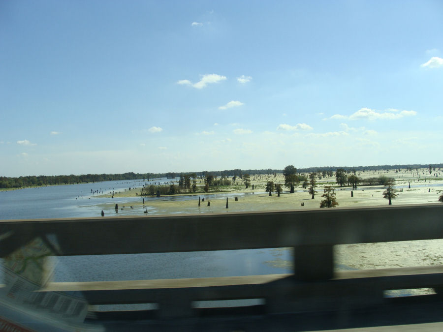
Bridge on Interstate 210 near Lake Charles, Louisiana

Here we are on the Interstate 10 between Lafayette and Baton Rouge. It's an elevated highway i.e. bridge. This stretch of 18.2 miles (29.3 km) is known as the Atchafalaya Swamp Freeway. It goes over the Atchafalaya River and the adjacent swamps.
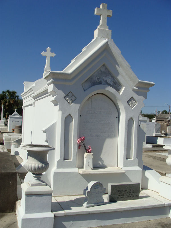
A stop in New Orleans at the Saint Patrick Cemetery Number two. More information about these cemeteries can be found here.


An amazing post Geke...so much to comment on...Some parts a little treacherous..loved the cactus and birds
ReplyDeleteHI Kay,
ReplyDeleteI enjoy your posts and currently looking for the latest of your "getaway to America" blogs...
I would like to see more pictures of Leroy & you making your way through the country side.
Well until next time we run into each other.
Harry
Mooie foto's mama! :-)
ReplyDeleteMila